
Page 59 - Maryland Historical Trust - Archaeology Colonial MD
P. 59
Catholic religious medals were found in the same area. While not definite, there is reference to a Jesuit brick “school of the humanities” at St. Mary’s in the late 1600s. This site could be the school. What is most fascinating is that it is somewhere between 1350 and 1425 feet from the square. Additional excavation will be need for a more precise measurement. Furthermore, the distance from the jail site to this cluster of brick is between 0.30 and 0.33 mile.
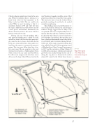
Having one pair of brick buildings half a mile apart and another pair at a third of a mile, and all four about 1400 feet from the square sim- ply cannot be due to chance. And when the five points are connected by lines, they radiate out- ward from the square in a symmetrical geometric pattern. The city streets follow these lines close- ly in most areas. The one exception is the most westward route known as Aldermanbury Street, which connects the city center and State House. It could not run straight as the other three streets do because the large Calvert House stood in the
way. Therefore, it jogged around the corner of that property and then ran toward the brick capital. The key factor here is that the Calvert House predated everything else and had to be worked around in any planning.
These findings were not at all what prior re- search had predicted. Instead, the archaeological evidence strongly suggest that St. Mary’s City was planned and not just a haphazardly built set- tlement. But when and who could have done this? Cecil Calvert had ordered a city to be laid out in 1633, but there is no evidence this was done, or at least it developed haphazardly even if they did lay it out. Political and social turmoil during the later 1640s and 1650s made any growth during that time unlikely. Only with Calvert regaining control of Maryland from Oliver Cromwell’s government in 1657 and the restoration of King Charles II in 1660 did circumstances stabilize and sustained growth become a reality. Perhaps the best clue for dating this city plan is to determine the earliest element? It cannot be the Calvert house because
figure 45
Map of the layout of St. Mary’s City from archaeological evidence.
57
