
Page 57 - Maryland Historical Trust - Archaeology Colonial MD
P. 57
inundated the area and moved the beach about 50 feet inland. But this did not stop the flow of this active spring, which is readily identifiable to divers as a zone of cold water coming out of the river bottom.33 Plotting the spring’s location shows that it aligns with several 17th-century fence lines running east-west that extended from the north side of Smith’s Ordinary. These fences defined the northern boundary of Smith’s Town- land and this evidence places the burned building on that tract, thereby providing strong proof that it was indeed Smith’s Ordinary. A nearby build- ing called the Lawyer’s Messuage is also known to have stood on this property.34
Gradually a map of the buildings, fences and other features in the city center began to be pieced together from the archaeology.There was a wide-open space in the center of this area, where the main city streets seemed to meet. While the streets may have been only 15 to 20 feet wide, this space was nearly 100 feet across and perhaps 150 feet long. But the most peculiar observation was that the nearest corners of the four build- ings (Calvert House, Smiths’ Ordinary, Lawyer’s Messuage and Cordea’s Hope) appeared to be 125
feet apart, forming a perfect square. This implied some intentional action to create an open space in the center of the community with the buildings, although being of different sizes and ages, sym- metrically placed in relation to each other. While not a huge discovery, it was a surprise given the unplanned nature of the city suggested by doc- uments. A market area is mentioned in the city charter and perhaps this wide space was intended to serve that purpose.
Given this square arrangement, the ques- tion then arose as to how other aspects of the city might have related to it. The four major streets of the city appeared to meet in this area. There were some documentary references to the roads and faint traces of two of the 17th-century streets could be observed in a series of aerial photographs of St. Mary’s City, beginning in 1933. Middle Street and the Mill Road were indicated by long subtle “crop marks” while only a few traces of the Chapel road were visible in part due to later landscape features.35 One reason these routes remained visible despite being unpaved and used for less than a century was finally discovered in 2014. Excavations along the presumed route of
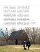
figure 43
A reconstruction
of Smith’s Ordinary based on its archaeology, showing the fencing that marked the northern boundary of the property.
55
