
Page 58 - Maryland Historical Trust - Archaeology Colonial MD
P. 58
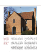
   figure 44
The reconstructed brick State House of 1676. It was re-built in 1933 from the original 1674 building contract and testing of its foundation in nearby Trinity Church cemetery.
Middle Street found that it had been bordered by a roadside ditch and fences. The ditches may have generated the “crop mark.” Fences found along the Van Sweringen site also indicated the route of Aldermanbury Street that ran from the city center to the brick State House.36
The most impressive buildings in the city were the two substantial brick structures, the Brick Chapel and State House. Their locations were now on the archaeology map and, out of curiosity, their distances from the center of the square were measured. Surprisingly these were the same, about 1400 feet center to center. A line drawn from the State House to the square cen- ter point and to the Chapel defined an angle of 140°, another curiosity. Measuring the distance
between these two brick structures produced the unexpected finding that they were exactly half a mile apart. These regular distances did not match the notion of a scattered village with no plan- ning. What about other brick buildings? One was the brick jail built at the same time as the State House. Its approximate location was shown on a 1787 map and bricks from it were located during a salvage archaeology effort on St. Mary’s College campus. The map location and brick were in the same place, with the actual site apparently under a paved road. When added to the map, this was also approximately 1400 feet from the central square. Another large cluster of brick was found at the east end of the city, not far from the original main land entrance over a 1638 mill dam. Several
56
