
Page 146 - Maryland Historical Trust - Archaeology Colonial MD
P. 146
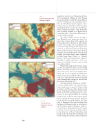
  figure 3
Viewshed from Mt. Airy Ossuary, Virginia.
expeditions were by Lucas Vázquez de Ayllón in 1525 and Ángel de Villafañe in 1561.9 Spanish Jesuits attempted to establish the Ajacán Mission in 1570 somewhere in the Chesapeake (possi- bly in the York River). Spanish explorers such as Captain Vincente Gonzalez in 1588 may have ventured into the bay as far up as the Potomac River. Gonzalez described a “large fresh-water river” located at a latitude of 38 degrees that he named San Pedro.10 The Potomac River begins at exactly 38 degrees latitude.
The earliest English presence in what is now Maryland comes twenty years after Gon- zalez when Captain John Smith explored the Chesapeake and its tributaries in 1608. Smith’s account of his voyages was accompanied by his now famous Map of Virginia. His map has since served as an important baseline for interpreting Native settlement in the Chesapeake at the time of initial contact with Europeans, albeit through English eyes. Smith depicts native settlements as either being “King’s Howses” or “Ordinary Howses,” which can be interpreted as represent- ing larger or smaller settlements, or those con- taining a local leader, weroance, tayac, or chief versus those without.
When Smith sailed into the Potomac in June of 1608 he traveled from what is now Cornfield Harbor in St. Mary’s County, across to the south side of the river in what is now Virginia. Here, Smith and his crew engaged the Sekakawons (Chicacoans) and possibly the Wiccocomicos, with peace “made all around” before the English party continued their journey for the falls near present-day Washington, DC.11
After departing the Sekakawons and Wic- cocomicos, Smith and his crew traveled north to what would later be named St. Clement’s Bay and then to the Wicomico River. Smith stopped by one of the larger settlements of chief ’s towns known as Secowocomoco (depicted as Cecomo- comoco on the map). From there he continued north-westerly to the Port Tobacco River (where he encountered the Potopaco), then Nanjemoy Creek, and then back to the Virginia side of the river to Patawomeck. He later encountered the settlement of Moyaons, which we now know as the Piscataway capital of Moyaone. Smith re- counts the tense relationship between Piscataway and their rivals the Patawomeck. Smith made it as far up the river as Nacotchtanke (Anacostan) on the south side of the Anacostia River. In all, Smith’s voyage in the Potomac lasted a little more
  144
figure 4
Viewshed from Nanzatico Ossuary, Virginia.
