
Page 144 - Maryland Historical Trust - Archaeology Colonial MD
P. 144
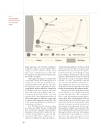
        figure 1
Late Woodland settlement model, after Strickland (2012).
     142
began appearing in the Piedmont, implying at minimum a change in ceramic traditions. These changes in both the Piedmont and the coastal plain ceramic assemblages have been used to infer the migration of people from the Piedmont into parts of the coastal plain.
At first glance, this appears to contradict the oral tradition held by the Piscataway people of a leader who came from the Eastern Shore. Ar- chaeologist Stephen Potter, however, argues that the discrepancy may be explained by an “inter- group alliance” made between those coming from the Piedmont and those already in the coastal plain, with a relationship forged by a leader com- ing from the Eastern Shore.3 What can be said, regardless of the correct interpretation of the oral history, there appears to have been a major shift in material culture taking place around AD 1300 in the Potomac and Patuxent river valleys, but to varying degrees of adoption.
Late Woodland period settlements along the lower and middle Potomac in Maryland have recently been examined using Geographic Information Systems (GIS) to identify the rela- tionships between different site types and their environments.4 The analysis of different site clas- sifications to different environmental variables re-
vealed statistically significant correlations, which can be summed up in table 1. In general, Late Woodland sites were located within close proxim- ity (if not directly adjacent to) wetland areas along major waterways, both along the Potomac shore and more inland tributaries. It was also observed that there were a range of correlations between particular site types, agriculturally productive soils, elevation, and slope. The relationships be- tween individual site types to these environmen- tal variables revealed variation, which was used to develop an interpretation and settlement model.
Throughout the tidal Chesapeake, proximity to open waterways is seen as an important feature of major village placement. This is understand- ably so, given that waterways provided food re- sources and a means of transportation. GIS also reveals another aspect of how these types of en- vironments can foster the visual experience of the landscape. Settlements located on waterways have the advantage (or disadvantage) of being open, which enhances visibility over vast distances. The role of visibility may have served several functions. Meaningful visibility could exist between places of spiritual and/or ritual significance, steward- ship of economic and environmental resources, and perhaps defensibility. Eric E. Jones used a
