
Page 147 - Maryland Historical Trust - Archaeology Colonial MD
P. 147
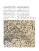
  than five weeks and, while he recorded little in text about his visits in that river, his map depicts settlements and their hierarchy as Smith under- stood them.
At this time, the Piscataway tayac, or lead- er, controlled much of Maryland’s lower western shore south of the Fall Line, with the exception of independent Patuxent villages and possibly the Yaocomico, who were nonetheless influenced by the Piscataway chiefdom.12 In his written ac- count, Smith gave estimates of the warrior popu- lations for the towns he visited. On the Maryland side of the Potomac, Smith estimated 40 warriors at Secowocomoco, 20 at Potopaco, 60 at Pama- cacack (Pomonkey), 80 at Nacotchtanke, and finally, 100 at Moyaone.13
Smith’s warrior counts have been used to come up with overall population estimates based on assumptions about the sizes of families to which warriors belonged. Estimates of the pop- ulation of the Piscataway chiefdom have varied, ranging between some 2,000 to as many as 7,000 individuals. These estimates reflect a number of different methodologies for calculating pop- ulation size and are based on assumptions of family sizes which are not without their flaws and weaknesses. Paul Cissna sought to reconcile these discrepancies by calculating a range of roughly 3,600 to 5,760 people living on the Maryland side of the Potomac at the advent of contact.14
At the time Smith and the Virginia colonists arrived in the Chesapeake, much of the native
figure 5
Capt. John Smith’s
Map of the Chesapeake.
        145
