
Page 114 - Maryland Historical Trust - Archaeology Colonial MD
P. 114
tack, 3 glass trade beads (ranging in date from 1560–1720), seeds, and stave fragments from the barrel that lined the well. All of this data suggested a well that may have been present as early as 1631, but which may have been open as late as 1725.21 In short, the well was old enough that it could be associated with the Claiborne Fort, but could also date to the period of occupation shortly thereafter.
The Claiborne Project contributors also made contact with John Chamberlin, who had collected for many years on Kent Island. Chamberlin had recovered dozens of kaolin pipestems, trade beads, and numerous melted glass “blobs” from the Kent Point beaches near the
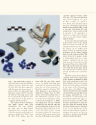
figure E
Artifacts recovered from the shoreline of Kent Point.
barrel well. The glass blobs turned out to be melted and fused glass beads which is particularly interesting given that one of the warehouses at Kent Fort burned on October 17th, 1631, destroying a good portion of Claiborne’s trading stock. In 1991, Darrin Lowery documented much of Mr. Chamberlin’s collection as part of a wide-scale archaeological survey of Kent Island funded by an MHT non-capital grant. He also officially recorded the site with the state and collected additional artifacts from the Kent point beaches during the course of the Kent Island survey.22 Among the artifacts collected by Lowery were many later 17th-century artifacts, but also glass trade beads (some melted),
a possible fragment of Dutch yellow brick, and 3 very thin and highly fired clay crucible fragments (see f igure E). These crucibles are similar to those known from late 16th-century sites such as Roanoke Island and the Frobisher Site on Hudson Bay, as well as very early 17th-century sites such as Jamestown23. Such crucibles would be expected at first generation or “exploratory” outposts where chemical assays on ore and mineral samples might be desired.
In one area of beach, between the location where most of the melted beads have been recovered and the submerged wells, Lowery also identified the remains of an eroding brick feature. In 1992, he conducted salvage excavations on the feature, digging three test units atop the remains. The feature proved to be largely a jumble of disarticulated bricks, but a bone fragment, a gunflint, and two trade beads were also recovered24 (one style documented from sites dating 1630– 1680, and the other from sites dating 1560–1720). The disarticulated feature may represent the secondary deposit of bricks and debris from somewhere nearby.
Kent Fort remains elusive. However, a growing body of data suggests that it was situated somewhere on Kent Point at the southernmost end of the Island. Whether that location remains fast land or has already been swallowed by the waters of the Chesapeake is anyone’s guess. According to 19th century Coastal Survey maps and 20th century USGS quad maps, Kent Point has changed significantly just in the last 170 years or so. The location of the aforementioned barrel wells appears to have been dry land as recently as 1960, but that is unfortunately no longer the case. As is often the case with sites in low-lying, tidewater areas of Maryland, we are in a race against time. It may well be that these handfuls of artifacts, enticing as they may be, are all we are ever likely to find of the first English settlement within Maryland.
112
