
Page 113 - Maryland Historical Trust - Archaeology Colonial MD
P. 113
nail, a Rhenish Brown stoneware sherd (generally declining in use by ca. 1675), a North Devon gravel- tempered basin (ca. 1650–1725), and a Susquehannock-style tulip pipe bowl. Darrin Lowery, a coastal geomorphologist with a research interest in archaeology, has suggested that the Craney Creek location may represent the now submerged remains of Claiborne’s personal plantation of Crayford (see figures A–C).18
Interestingly, the site is a little over 6 miles from the Kent Point area, which is the most likely location of Claiborne’s Fort. Recall that the 1638 letter describing Leonard Calvert’s capture of the island states that he landed at the southern end of Kent Island, captured the fort, and then marched about 5 miles over land to where the plantations of Butler and Smith lay across a creek from one another (possibly Shipping Creek). Calvert then travelled two miles
overland to Crayford where his pinnace had been sent. Many archaeologists have searched Kent Point for signs of the fort, but no one has been able to locate it. In May of 1965, Thomas Elton Beam (a member of the Archeological Society of Maryland) conducted a small survey in a field on the Kent Fort Manor property, but only identified prehistoric artifacts.19 In 1977, and again in 1981, Kit Wesler carried out extensive surveys in the plowed fields of Kent Point and along the shoreline all the way up to Tanner’s Creek as part of his dissertation fieldwork. Wesler recorded several prehistoric and historic sites, but was unable to locate any 17th-century sites on the point.20
In the late 1980s and early 1990s a consortium of amateur underwater archaeologists, Chesapeake historians, and other researchers contributed to an undertaking known as “The Claiborne Project,” whereby they
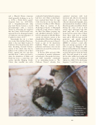
conducted interviews with local watermen and collectors, documented private collections from the island, collected infrared photographic data, and examined the shorelines of Kent Island (especially around Kent Point). During the course of one of their surveys, three submerged wells (two barrel wells and a box well) were located off the eastern shore of Kent Point. These wells were in shallow water and in 1990, the team received permission and partial funding from the Maryland Historical Trust (MHT) to construct a small coffer dam and attempt excavation of the wells (see f igure D). Though the coffer dam proved insufficient, the Claiborne Project group was able to successfully excavate the interiors of the two barrel wells. One well proved to be sterile, but the other yielded rose-headed nail fragments, a piece of Staffordshire slipware (ca. 1660–1725), a kaolin pipe fragment, 1 small brass pin, a brass
111
figure D
Excavation of a colonial barrel well by researchers with the Claiborne Project in 1990.
PHOTOGRAPH COURTESY OF MICHAEL POHUSKI.
