
Page 82 - Maryland Historical Trust - Archaeology Colonial MD
P. 82
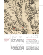
   figure 24
Portion of Augustine Herman’s Map of Maryland and Virginia showing Mattapany, Notley Hall, and My Lord’s Gift.
ports of entry, had also become important polit- ical landmarks in the colony.48 Charleston, too, was destined to become a political landmark, and a richly symbolic one given its previous associa- tion with the rebel Fendall. Meanwhile, council member Henry Coursey appears to have mim- icked the form, style, and siting of Mattapany and Notley Hall, and it is likely that other pro- prietary officials did so as well. At a time when most colonists were adapting the simple earthfast form known as the “Virginia house,”49 Charles Calvert, Thomas Notley, and William Digges were signaling not only their economic and social status, but the proprietary family’s unmistakable presence across the colony. Perhaps most tellingly, it is these places, including Mattapany, Notley Hall, and My Lord’s Gift, that Cecil Calvert, the second Lord Baltimore, insisted appear on
Augustine Herman’s Map of Maryland and Vir- ginia published in 1672: a map that shaped how Maryland appeared in the English imagination.
Plantations in an Era of Stability
As members of the Calvert family and their asso- ciates were building plantations in strategic loca- tions to assert their authority, the majority of free men and women were building their own plan- tations in an effort to create wealth. These free colonists had the help of a steady supply of ser- vants (most of whom were English) who served four to seven years before gaining their own free- dom. Africans, who had been in the colony from first settlement, formed a small but nonetheless growing portion of the colonial population, and most of these individuals were enslaved. Indeed, the Calvert family promoted the use of slaves, a
80
