
Page 74 - Maryland Historical Trust - Archaeology Colonial MD
P. 74
finding on-the-ground leadership in the colony that he could trust. Cecil had appointed his younger half- brother, Philip, as governor following Fendall’s Rebellion, and Philip had moved swiftly and decisively to re- store the Calvert government, issuing at least one proclamation among the plantations at “Indian Quarter near Newtowne.”37 Baltimore replaced his half-brother in 1661, sending the 24-year-old Charles to assume lead- ership of the colony. Perhaps not sur- prisingly, given the struggles faced by the colony in its initial years, Charles found the situation in Maryland disor- ganized. With his father’s direction, he took charge of the land records offiffice
Digital Data –
Archaeology At Your Fingertips
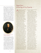
figure 14
Portrait of Charles Calvert, Governor and Third Lord Baltimore.
(especially with regard to his father’s manors), incorporated St. Mary’s City, encouraged legislation to establish towns, and negotiated articles of peace with the neighboring Indian groups.
Governor Calvert also under- stood the importance of geography for asserting Calvert family authority, an insight he had gained from his family’s experiences in Ireland and Newfound- land. The younger Calvert worked with his father’s Council in the colony to create counties where appointees could more effectively represent proprietary aims. Legislation to create towns, an effort tried a number of times in late
Archaeologists collect massive quantities of data! Even before fieldwork is carried
out, background research will be conducted and synthesized and
then used to inform the research design. From the first day of a
field project, spatial information is collected, recorded, and mapped
on field forms and site plans. In
the lab, artifacts will be examined, described, photographed, analyzed, and prepared for permanent curation. All of these activities generate
data that is then used to inform the interpretations of a given site.
Print publications are the traditional means by which data
are disseminated to the broader community interested in archaeology. But any particular journal subscription is likely to have a fairly limited audience, and the print media format can sometimes be limiting in how data can be presented (i.e. there
are only so many ways to display a data table on paper). In addition, the proliferation of “gray literature” has intensified since the inception of the National Historic Preservation Act of 1966. Unpublished cultural resource management (CRM) reports often become “reburied” in the offices of a single state repository and research librarians have long complained about the particular difficulties of obtaining archaeological information for their patrons. But increasingly, archaeologists are turning to the internet as a means of disseminating their data. The seemingly ever- expanding issues related to “Digital Data” are a frequent topic of conversation at professional meetings and on online archaeology discussion boards. Here we’ll take a brief look at two digital offerings pertinent to the Archaeology of Colonial Maryland.
THE MARYLAND ARCHEOLOGICAL SYNTHESIS PROJECT
On Maryland Day (March 25th), 2015 the Maryland Historical Trust’s Office of Archeology launched a new online tool to provide members of
the public with greater access to data obtained through tax-payer funded and publicly mandated archaeological research. Funded by generous support from the Maryland Historical Trust (MHT) Board of Trustees
and the Maryland State Highway Administration’s Transportation Enhancement Program, the Maryland Archeological Synthesis Project
has been underway since late 2007, reviewing the over 50 years of archaeological site reports generated in compliance with the National Historic Preservation Act of 1966 and similar state and local legislation.
The overall goal of the project has been to characterize this data for
as wide an audience as possible, to make it searchable, and to make the information more accessible.
This Archeological Synthesis database is an online catalog of archaeological sites within the
state where Phase II and Phase III test excavations have taken place (i.e. research geared towards characterization of a site or recovery of data, as opposed to merely identification of sites). Focusing on research that is largely driven by compliance with state and federal legislation, the database is linked to MHT’s Site Survey files, but is also tied to synopsis reports and cover sheets generated by reviewing larger excavation reports. The synopsis reports contain capsule summaries of the overall site reports, organized so researchers or members of the public can quickly pull out the most relevant information needed for determining if a particular site is of
72
IMAGE COURTESY OF HISTORIC ST. MARY’S CITY.
