
Page 152 - Maryland Historical Trust - Archaeology Colonial MD
P. 152
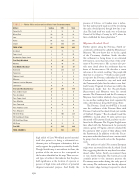
    TABLE 2 — Native lithic and ceramic artifacts from Secowocomoco.
      Artifact
Potomac Creek
Surface
STPs
Units
      Projectile Pt.
8
13
9
      Biface/Tool
29
26
28
      Core
22
17
11
      Flakes
64
722
591
      Shatter
89
440
291
         TOTAL LITHIC
212
1218
930
      Accokeek
2
15
13
      Popes Creek
2
28
44
      Accokeek or Popes Creek
1
3
0
      Total Early Woodland
5
46
57
      Mockley
0
46
19
      Total Middle Woodland
0
46
19
         Townsend
15
284
323
      Yeocomico
0
5
0
      1
4
9
      Moyaone
2
2
0
      Potomac Creek or Moyaone
2
3
0
      Colonoware
0
0
7
      Total Late Woodland/Contact
20
298
339
      Poss. Selden Island
0
2
0
      Poss. Accokeek
0
5
0
      Poss. Popes Creek
0
8
0
      Poss. Mockley
4
9
0
      Poss. Townsend
UID Sand/Quartz Temp.
4
38
0
      Poss. Potomac Creek
0
1
0
      Poss. Moyaone
0
6
0
      UID Shell Temp.
7
106
229
      1
6
18
      UID Shell/Sand Temp.
0
1
0
      UID Temp.
0
11
17
      Total UID
16
193
264
         TOTAL CERAMICS
41
583
679
 150
high yields of Late Woodland period material itself also point to it being a substantial set- tlement prior to European colonization, able to easily support the population as noted by Smith. Though Smith’s map is not without its flaws, the position of the site more or less corresponds to the location identified on his map. There are sev- eral types of artifacts that indicate that the place held significance as the location of a person or persons of high status and artifacts of potential religious/ceremonial purpose. And finally, the
presence of Colono- or Camden ware is indica- tive that native people made use of the site during the early colonial period, though how late is un- clear. The land itself was made over to Justinian Gerard of St. Mary’s County by 1673, where he later established his home plantation.28
Moyaone/Accokeek Creek
Further upriver along the Potomac, Smith en- countered a settlement he called the Moyawance/ Moyaons. We now know this to be the capital of the Piscataway chiefdom. Smith describes this settlement as being home to an estimated 100 warriors, more than twice that of the settle- ment of Secowocomoco. His accounts also pro- vide more detail about the settlement than we know of Secowocomoco. He describes a warm welcome at his arrival, recalling “the people did their best to content us.”29 Smith recounts anoth- er trip into the Potomac undertaken by Captain Croshaw who intended to stay and trade with the Patawomeck (who lived in what is now Staf- ford County, Virginia). Croshaw was told by the Patawomeck leader that the Nacatotchtanks (Anacostans) and Moyaons were his mortal enemies. The Patawomeck and the Piscataway at Moyaone lived within relatively close proximity to one another, making them rivals separated by only a short distance along the Potomac River.
The Potomac Creek site (44ST2) is located near the confluence of the Potomac River with Potomac Creek and Accokeek Creek, just outside of Stafford, Virginia.30 The Accokeek Creek Site (18PR8) is located about 30 miles upriver near the mouth of Piscataway Creek, and was once be- lieved to be Moyaone. The Virginia English were later allied with the Patawomeck. As previously stated, a group of Virginia colonists attacked the Piscataway in 1623 as part of their alliance with the Patawomeck. In addition to this the Piscat- away were under the threat of near-constant raids by groups from the north such as the Susquehan- nock.
No artifacts of early 17th-century European origin were uncovered from the Accokeek Creek Site, suggesting that the site may have been aban- doned either before Smith encountered them or very shortly thereafter. The historical record certainly points to the immense pressure the Piscataway were under during the early part of the century. The settlement was directly adjacent to the water’s edge, leaving it exposed to attack
