
Page 129 - Maryland Historical Trust - Archaeology Colonial MD
P. 129
covered, primarily from the northeastern half of the structure.This represents a much higher quan- tity of ammunition than was recovered from any other Charles Town site (see table 2). The overall assemblage supports the idea that the building’s principle function was the storage of commercial goods, and perhaps hogsheads of tobacco.
A second set of structures was uncovered to the south of Terrace B (see figure 11). This collec- tion of buildings was designated “Terrace Site A.” The most substantial structure was an 18 by 24 foot dwelling (figure 8, Building F) oriented with the long axis parallel to the river.This building was constructed with bents at approximately 8 foot intervals. The lack of artifacts recovered from the post holes indicate the building was the first im- provement to the lot. A brick-based chimney on the southern gable end and an 8 by 16 foot shed on the river side were later added to the building. A smaller 15 by 20 foot quarter (Feature 8, Build- ing E) was added to the lot sometime after the dwelling was first erected. A doorway was indi- cated on the river side and a 3 foot cellar hole was located near the center of the structure. Several posts were uncovered to the north of this quarter that may indicate a third structure in line with the first two (Feature 8, Building G). One large arti- fact filled pit excavated to gather clay perhaps for a daub chimney was uncovered below the north wall of the quarter. Two smaller pits were discov- ered to the north of the quarter. All of the build- ings are in perfect alignment with the 20 by 40 foot structure (Building H) on the adjacent lot to the north.
At least one other structure was identified to the south of these buildings. This building was identified through a deep rubble filled feature near the current park road. Three 5 by 5 foot units were excavated over this feature but the fill within the feature was not excavated.The northern extent of the feature was identified, but the majority of the feature extended well to the south of the exca- vations. The depth of the feature suggests a cellar, and the artifacts from the stratum above and pro- truding from the surface suggest a Charles Town era structure possibly related to the dwelling and quarter to the north. Ground Penetrating Radar (GPR) and Magnetometer (MAG) data suggest the cellar is perhaps 8 by 10 feet or larger.32
A final building is suggested in the field just south of the cellar hole (figure 8, Building C). A concentration of ball clay tobacco pipes and ceramics was identified during shovel testing in
gure 9
AutoCAD drawing showing features and layout of Building H at Terrace Site B.
fi
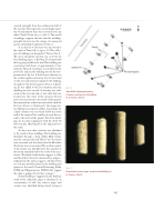
figure 10
Rouletted tobacco pipe stems from Building H at Terrace Site B.
127
PHOTOGRAPH COURTESY OF THE MARYLAND-NATIONAL CAPITAL PARK AND PLANNING COMMISSION.
