
Page 124 - Maryland Historical Trust - Archaeology Colonial MD
P. 124
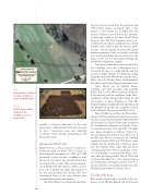
 figure 3
Approximate location of James Stoddert’s house on Beall’s Gift.
figure 4
Hearth and possible midden at the Stoddert house on Beall’s Gift.
ing site were recovered from the plowzone and 19th-century artifacts associated with a slave quarter in the vicinity are excluded from the analysis. Artifacts recovered from the plowzone include types similar to the other Charles Town domestic sites. Few brick fragments were recov- ered from the excavations, and the presence of lead window cames indicate that the primary dwell- ing was a post-in-ground structure with glazed window treatments. Only one possible structural post was located during the excavations, but the extent of the site was determined through the distribution of plowzone artifacts.
Two factors made this location an ideal spot for a dwelling. First, the archaeological site is located at the apex of a slight hill. Second, this location is within 250 feet of a freshwater spring along the bank of the Western Branch side marsh. This is the only Charles Town site identified to date that is not located along the main town road.
James Moore was an ordinary keeper, constable, and land speculator who patented Beall’s Gift in 1702. Moore retained a half-acre lot located very near the confluence of the West- ern Branch and the Patuxent River when he sold the property to James Stoddert in 1704. The Stoddert family owned Beall’s Gift until they sold the property along with the remainder of their land at Mount Calvert to James Pelly in 1732.
James Stoddert moved from his Yarrow plan- tation on the Eastern Branch of the Potomac (now the Anacostia) sometime between 1700 and 1702, and remained in Charles Town until moving to his Southampton plantation in Charles Coun- ty sometime between 1711 and 1713.25 Stoddert was living elsewhere at Mount Calvert be- fore purchasing the property from Moore. It is possible that Moore constructed the dwelling sometime between 1700 and 1704, but it seems unlikely that he would retain a half-acre parcel near the Patuxent River, rather than the parcel containing the house. The most probable scenar- io is that Stoddert constructed the house some- time after purchasing Beall’s Gift in 1704, and may have lived there for a time until moving to his Southampton plantation around 1713. It is also possible that a tenant lived in the house after Stoddert had moved from Charles Town.26
The End of the Road
The second activity node is located at the con- fluence of the Western Branch and the Patuxent
 122
provides a composite illustration of the town layout when combined with the historical record. At least 5 interaction areas were identified at Charles Town through archaeological and historical research.
Springhead at Beall’s Gift
Beall’s Gift was a 16-acre parcel of land locat- ed directly north of Charles Town (see figure 3). Archaeological excavations in 1997 and 1999 uncovered a scatter of refuse, a midden or trash pit, one structural post, and a possible hearth area associated with an early 18th-century domestic site at Beall’s Gift. The purpose of these excava- tions was to identify the extent and integrity of the site, and document the features that were encountered. None of the intact features were excavated during these investigations.
All of the artifacts associated with the dwell-
    PHOTOGRAPH BY MICHAEL T. LUCAS, COURTESY OF THE MARYLAND-NATIONAL CAPITAL PARK AND PLANNING COMMISSION.
MAP BY SUSAN WINCHELL-SWEENEY.
