
Page 106 - Maryland Historical Trust - Archaeology Colonial MD
P. 106
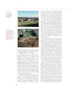
  figure 14
17th century cccupations at Herrington (18AN1214).
figure 15
The 18th century William Brown House at London Town, with excavations in-progress at Rumney’s Tavern in the foreground.
pits in the vicinity of what is still known today as “Town Point” in their search. But rather than locating the town close to the shore, where all of the 17th century sites had been located at Prov- idence, the settlement was identified further in- land, strung out on the heights above Town Point.
As the test excavations expanded outward along a local road, artifacts dating to the mid- 1600s began to be discovered. These included ce- ramics like Dutch delftware, English sgraffito and border ware, and German salt-glazed stoneware. As was the case at Providence, transportation played a role in the layout of the town. However, it was not access to water for boats that impact- ed the layout of Herrington. Rather, the town was situated along the main access road leading to the interior. The locations of the 17th century occupations identified at Herrington thus-far are shown as black silhouettes in the modern photo- graph of figure 14.
A third town pattern was encountered at London on the South River.13 London Town (18AN48) was a legislatively mandated settle- ment founded later in the century and was rigidly laid out on a grid encompassing one hundred one acre lots. Unlike Herrington and the various sites associated with Providence, there was no search for London Town. The William Brown House and Tavern still stands at Historic London Town along with other buildings reconstructed on their original locations, and the site has operated as a County Park open to the public since 1965. Nev- ertheless, a tremendous amount of archaeology was needed to find clues to the layout of the late 17th century town. The Brown House and one other building situated outside the park are the only structures still extant from the early town.
The town site is situated on a peninsula over- looking the South River to the north and east, upriver from where it empties into the Chesa- peake Bay. The Town of London was created by the Maryland Colonial Legislature in 1683 by the “Act for Advancing the Trade of Tobacco” which created (at least on paper) official “ports of entry,” and specifically reserved a portion of the Burgess property on the South River to be the site of one such town. The Act required any import or export activity to pass through one of the “official” port towns. These towns (including London) were laid out on 100 acre sites, divided into lots of approximately one acre each. Each lot owner was then obligated to build a structure of no less than 400 square feet or risk forfeiture of
  104
And by 1670, the town was considered a signifi- cant enough settlement to be depicted on Augus- tine Herman’s Map of the Chesapeake.
Herrington also was a major center of Quaker settlement. Several accounts survive of Quaker missionaries active in “Herring Creek Hundred” (i.e. Herrington). Meetings of the Quaker Society of Friends were held on a week- ly basis in the homes of a number of the known Herrington property owners. A number of these Quaker property owners went on to hold positions of political significance and had connections at a high level in the colonial government. By 1683, the townspeople were able to use their political influence to have Herrington designated an offi- cial “port of entry” to regulate shipping. Despite all of this early success, the town had virtually disappeared by the early 1700s.
The townsite was rediscovered in the year 2000. In that year, the Maryland Historical Trust awarded a non-capital grant to Anne Arun- del County’s Lost Towns Project specifically to search for evidence of Herrington. Lost Towns archaeologists dug over seven hundred shovel test
