
Page 17 - Georgia Forestry - Issue2 - Spring 2018
P. 17
LiDAR
LiDAR is a scanning tool that uses lasers to measure objects and create three-di- mensional models that can then be used for a variety of applications. LiDAR scan- ners work by emitting light in the form of a pulsed laser and collecting reflected
TALL TIMBERS
points (i.e., ‘returns’). Each time the pulsed laser hits an object, like a tree branch, the light is reflected back and creates a cloud of points that effectively measures distance from the scanner to the object. These point clouds can then be viewed as three-dimensional models.
Typically, LiDAR scanners are flown
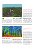
A landscape at Eglin Air Force Base mapped for tree density by the US Forest Service using airborne LiDAR. Watch a video of this LiDAR model at: www.georgiaforestrymagazine.com/LIDAR.
from an aircraft yielding one to five laser ‘returns’ per square meter. Referred to as airborne LiDAR, the application of LiDAR technology at this scale is used to create contoured maps of topography or forests that can be used in fire man- agement. This represents a great leap forward for mapping three-dimensional fuel characteristics and forest types.
Benefits of LiDAR at this scale include the ability to look at geography and forest structure over large areas and much of the United States have these datasets freely available from public sources. The disadvantage is that we are not able to see these areas at a fine resolution.
A Terrestrial LiDAR Scan of a mature longleaf tract showing highly detailed forest structure.
from 1 acre using TLS to a half-million acres using airborne LiDAR.
Tall Timbers Wildland Fire Scientist Kevin Hiers is working with Dr. Eric Rowell at the University of Montana Fire Center and Dr. Louise Loudermilk at the US Forest Service Southern Research Station to apply the TLS equipment on a variety of projects within longleaf pine forest ecosystems.
These researchers, along with others across the US, have formed the Prescribed Fire Science Consortium to study and leverage technology to further our under- standing of prescribed fire. This effort is providing unprecedented detail of forest structure, fuel loading, and spatial variation in understory and midstory vegetation. The Consortium has a variety of ways to apply this technology.
Ground-Based Scanning
Ground-based Terrestrial Laser Scanning (TLS) is used frequently in engineering and architectural fields. It is helping to bridge the gap between fine scales (1-2 acres) and coarse airborne LiDAR data (many square miles). By using a
TALL TIMBERS
stationary TLS system, the resolution of the point cloud is increased 750,000 fold from airborne LiDAR resulting in near photographic three-dimensional models that can be measured and analyzed.
Researchers led by Tall Timbers scientists, have leveraged this technology to map trees and fuels at scales ranging
www.GeorgiaForestryMagazine.com | 15
